
By Dan Pennington
What are the driving factors in fire severity? Depending on where you source your information, you will likely find an array of answers, most of them leaning into the concept that more woody material, equals more fuel, which equals greater fire severity. But this umbrella explanation ignores the vast ecological and environmental differences of forests within unique bioregions. For example, we would not expect fire in coastal fog-belt Redwood forests of California to behave the same as fire in dry White Fir and Ponderosa Pine forests on the eastern slopes of the Cascades. A “one size fits all” approach to reducing fire damage potential does not exist, and in fact, there may be counter-intuitive solutions depending on the forest being analyzed.
One such forest is the Coast Range of Oregon, and to some extent, the western-slope forests in the Cascades. Somewhere along the spectrum of wet fog-belt Redwood forests and dry eastern pine forests lie these forests of western Oregon, capable of growing firs nearly as tall as the largest Redwoods, while also enduring unique weather conditions — at times draped in a thick blanket of fog, and other times dried out by hot easterly winds originating from the Oregon desert, reminiscent of California’s notorious Santa Anas.
So what is the most significant driving factor of forest fire severity in western Oregon? It isn’t the amount of flammable material existent in a given forest. No, the driving force are the weather conditions that set the stage for a spark to turn into a conflagration – weather conditions that are becoming more volatile and frequent because of a rapidly changing climate.
This September we experienced one such weather event. Billed as a twice a century weather pattern, dry and hot easterly winds met a high pressure ridge from the Pacific and the two squared off over Oregon, creating the dry and windy conditions capable of burning over a million acres of western forests within a matter of days.
Three of the largest fires in Oregon this year appeared to behave counter to the more wood/more fuel/worse fire narrative. While many fires seem to begin on public land where accessibility brings people near to forests, when the fires grew and stretched into the private industrial tree farms, it didn’t appear to slow like would have been expected with the reduction of fuels. By simply comparing satellite data to mapped radiative energy, it appears the fires may have actually accelerated and burned with more severity in lands that were heavily logged at one time or another.
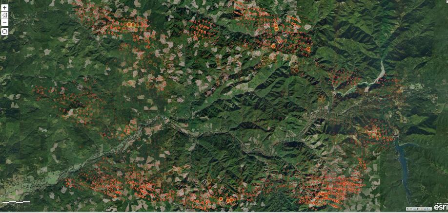
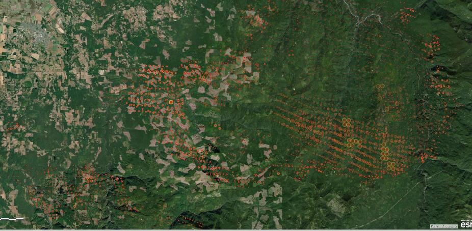
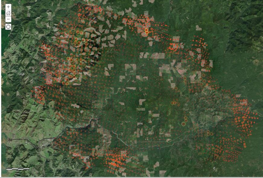
The above satellite imagery gives a cursory glimpse of forest composition where three large fires took place. Within the boundary of each of the three fires exists a large tract of land with patchwork industrial tree farm operations – these are the scattered brown patches amongst the forest green. Overlaying this backdrop is a data layer constructed by a satellite measuring thermal hotspots (called VIIRS). Each of the red dots on the map represents the fire radiative energy in a given location at the time the satellite passed overhead (the bigger the dot the higher the radiative energy measured). Based on this limited look we can gather from high in space, the fire didn’t have less radiative power on reprod tree farmed land as would be expected by proponents for cutting trees to reduce fire severity. In fact, the opposite appears to be true as higher radiative power was measured on tree plantations than much of the contiguous public forest. The caveat is that this data is not conclusive and feet on the ground will be necessary to come up with granular detail about how these fires behaved, but one thing is for certain, tree farms did not slow these fires down.
The conclusion that severe weather, not a preponderance of fuels, was the driver of fire severity was noteworthy in 2018 when two scientists Dr. Harold Zald formerly from Humboldt State University and Dr. Christopher Dunn from Oregon State University analyzed fire severity in southern Oregon. They also found that fire burned with more severity on private industrial logging lands than it did in older public forests. It was also noteworthy back in 2010 when Joy Drohan penned a research paper analyzing the Biscuit fire and determined, “Stands of large conifers were least likely to burn with high severity.”
So why were forests that held more fuel potential not damaged as badly as the tree farms governed under private logging laws? The answer isn’t 100% clear, but there are a number of reasons that help shed light. For one, reprod tree farms do actually contain significant fuel levels, as oils are locked into foliage, which tends to be packed tightly on branches stacked at the same height, meaning fire has an easy pathway and many volatile oils to sustain its movement over the entire stand. Some of these plantations even house trees as close together as 8 feet apart. Second, mature western forests in Oregon have 50% more summertime water flow than nearby established tree farms. More moisture in the ground gives trees additional protection when dry weather conditions sit over an area. Third, our Coast Range forests accumulate significant summer moisture from the air as high-ridgetop trees grab and condense fog from the convection flow of moist ocean air. Some of these forests can accumulate 30% more precipitation than comparable clear-cut areas, with as much as 44% of their spring and summer precipitation coming from fog alone. Lastly, old forests in western Oregon are not readily prone to ignite. Their trunks, while full of fuels, are protected by thick fire-retardant bark, the ambient temperature within the understory is cooler, and their canopies often stretch beyond the reach of flames.
A way to think of a wildfire is similar to starting a fire in a woodstove. You don’t begin by attempting to light a big wet log; rather you build the fire up from kindling before adding larger fuels. Forest fires behave in much of the same way, meaning if you want to burn an old forest, you’re going to need quite a “ladder” of smaller fuels to get there.
A look at modern history tells us that once Coast Range forests have burned and reseed with brush and small trees, they sometimes subsequently burned with greater regularity. The series of fires that swept through the Tillamook forest burned in rapid succession over a period of years, suggesting that young forests may be more susceptible to fire frequency than their older counterparts. Similarly, the Biscuit Fire showed increased burn severity in areas that had previously been burned 15 years prior. The historical data backs that up. Before western settlers came to Oregon, the average age of a Coast Range Forest between fires was 406 years.
This is not to say that old forests do not burn. They certainly do, and in the right weather conditions nothing will stop an inferno that is fueled by hot, dry wind as we saw this month. However, records of fire history in the Coast Range of Oregon depicts that not only had it been hundreds of years between large stand-replacement fires prior to the arrival of the settlers, but these coastal forests were also estimated to be composed of over 90% trees aged above 100 years and a staggering 61% of the entire forest was old-growth.
After the arrival of the settlers a number of fires changed the landscape of Coast Range, starting with a series of fires in the late 1840s that removed an entire 1/3rd of these coastal Oregon forests (Map). Most of these fires have been attributed to the western settlers who opened up new land for their settlements and whose activities in the region became a spark for a number of fires to take hold. As is the case with the latest fires in Oregon, the conflagrations of the 1840s were likely fueled by dry weather as determined from tree ring analysis.
But fire was not new to the region. Native peoples used fire regularly for a variety of reasons, including to support easy travel on ridgetop trails, to open up understory for better hunting or clear the land for favorable foraging. This low-intensity, frequent burning reduced the understory in forests which, in turn, took off rungs of the so-called ladder of fuels by which the fire reaches the canopy. While it is fair to say that the native people used fire as an integral part of life, they likely did so as a land treatment only during times of the year that there was little chance for an out-of-control blaze to find purchase.
This leaves us with two problems. One is our changing climate. It is quickly altering our ecosystem with an increase in rare weather events and drought stressed regions. The second is an increase in dangerous human activity within our forested areas, which in turn increase the likelihood of spark events. One fire this year was caused by a motorhome dragging chains on the highway. Another was started by a man dismayed over a break-up with his girlfriend. The large Holiday Farm and Beachie Creek Fires in the western Cascades likely began with downed power lines. Whether it was stupidity, infrastructure decisions (or lack thereof), or malignant intention, western civilization has not only become the nexus for the increase in spark events, but now also the driver for the acceleration of climate conditions that turn those sparks into incendiary devastation.
So what can be done?
For one, our rural communities are in need of improved mental health services. The lone-wolf types arrested for starting fires this year are people that could have benefited from easier access to mental health professionals. Law and order is simply not enough to dissuade potential arsons. Resources poured into improving mental health, may be one investment that pays dividends for the safety of our communities down the road.
We can also put pressure on our utility companies to be proactive in shutting down the grid when weather conditions threaten conflagrations. Normalizing the public to power outages during high-wind events could go a long way in saving communities from the fate that befell Blue River, Gates, Mill City, Paradise and a number of other small rural enclaves that pepper forested areas in the Northwest. Similarly, investing in burying power lines where the impact is ecologically minimal would also result in a reduction of spark events caused by wind and downed trees.
A whole-sale rejection of the Jordan Cove Pipeline, which would bore a pathway through fire-prone forests, is also a necessary, sensible preventative measure. The proposed three foot wide pipe that would use our forests to deliver natural gas to Asian markets is pressure filled with highly flammable gas that could ignite a worst-case fire scenario for communities along its route. Whether it’s a breach caused by faulty construction, a natural disaster like an earthquake, or a malicious arsonist, an explosion from the pipeline could create the type of fire event with zero warning and immense damage potential to surrounding forests, property, and life.
There’s also an argument for increasing the spending on fire suppression west of the Cascades. This means more wildland fire-fighters, an increase in air support, and an investment in technology that helps identify and track fires before they have a chance to spread. Currently, there’s a number of satellites, like the one taking VIIRS imagery mentioned earlier, that give valuable information on the location and spread of fires, but there may be 12 hours between overhead passes. Whether it is putting up additional satellites to monitor for fires or coordinating the usage of established satellites to help monitor during emergencies, we need to task our government to find ways to track fires with greater regularity from above, informing decision makers where to allocate resources in real time.
Lastly, this February Senate Bill 1536 sat in Oregon’s congress waiting for a vote during the GOP walk-out. The bill would have fire hardened communities by implementing building codes that require defensible space around homes, fire-proofing new homes with materials less susceptible to ignition, and retrofitting older homes over time to improve their fire safety. Also, according to Governor Brown, Senate Bill 1536, “Would’ve provided the Office of Emergency Management with additional resources to help our communities with evacuation plans and would’ve provided Oregonians additional assistance to recover when wildfire affects their communities.” Reminding our legislators to put the lives of Oregonians ahead of the partisan antics that led to legislative inaction earlier this year is key to unlocking the funds and laws necessary to help our fire prone communities. But it must be made clear to legislators, that any future bill written to deal with fires in the western Cascades and Coast Range must not include language that would increase logging under the guise of fuel removal. Rather, the language should reflect the need to return more of our public forests into stands of mature timber, capable of withstanding fire severity better than their privately managed counterparts.

